Principle #1
Step 1: Create a Base Map
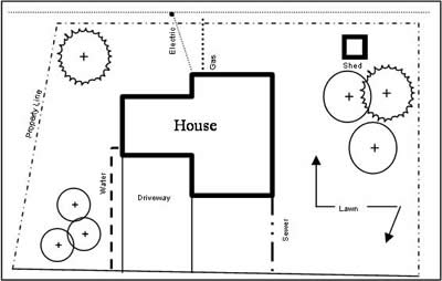
The goal of your base map is to create a simple scale
drawing of your yard and its characteristics, which
is very easy to do. You should include the house, driveway,
walkway, existing trees, shrubs, plants, fences, outbuildings
and any other major features of your yard. Don’t
forget to note any overhead power lines and buried utilities
that could be affected by plantings. To locate buried
utilities, call the Colorado “one call”
line location service at 800-922-1987. All landscape
projects must take this precautionary step before work
begins. The service is usually free of charge and is
required before any digging is started. Line locates
are usually completed within three days of the request.
Begin your drawing by using graph paper. This will
make it easier to plot your yard to an appropriate scale.
A couple of good scales to use for residences are 1/8”
= 1’, or 1” = 10’ To create a base
map of your project, simply measure your yard using
a tape measure. A 100’ tape measure is ideal.
<<
Go back
|